Scan to BIM Services: Point Cloud to Revit
As-built Revit models of existing buildings from your laser scan, for renovation, retrofit, fit-out and heritage projects, at the LOD and tolerance you set.
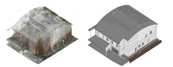
BIM365 provides Scan to BIM services for architects, engineers, contractors, surveyors and building owners. You send the registered point cloud; we model the building as it really stands, so your design starts from facts instead of drawings that stopped matching the site years ago.
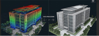
We process scans in Autodesk ReCap and model in Revit, to your template and naming rules. Every model is checked against the point cloud by a senior BIM coordinator before handover. See all our BIM services.
Scope
What We Model From Your Scan
Architecture
Walls, floors, roofs, ceilings, stairs, doors and windows, modeled to the scan with real thicknesses and levels.
Structure
Columns, beams, slabs, trusses and steel frames where visible, set out on a grid that matches the building.
Visible MEP
Exposed ductwork, pipework, cable trays and plant, so new services can be routed around what is already there.
Facades & Heritage
Facade openings, cornices and ornamental detail modeled to the level the conservation brief or design team needs.
As-Built Drawings
Plans, sections, elevations and reflected ceiling plans taken from the model, on your title block.
Deviation Checks
Model compared with the point cloud to show where walls are out of plumb or floors are not level, when the brief asks for it.
Level of detail
Choose the LOD for Your Project
More detail costs more time. Pick the LOD by what the model will be used for, and we agree the tolerance before modeling starts.
| LOD | What the model shows | Typical use |
|---|---|---|
| LOD 200 | Main walls, floors, roof, openings and grids with approximate thickness. | Space planning, feasibility, area checks. |
| LOD 300 | Accurate walls, floors, structure, doors, windows, stairs and visible MEP mains. | Renovation design, fit-out, MEP retrofit. |
| LOD 350 to 400 | LOD 300 plus detailed connections, MEP branches, fixtures and facade detail. | Coordination for construction, prefabrication, heritage records. |

How it works
From Point Cloud to Revit Model
- Scan check. We open the point cloud, check registration, coverage and density, and flag any gaps before quoting.
- Scope, LOD and tolerance. Agreed in writing: what is modeled, to what LOD, and how close to the scan.
- Set-up. Point cloud linked into your Revit template, levels and grids set out from the scan.
- Modeling. Architecture, structure and visible MEP modeled area by area against the point cloud.
- Check and handover. Model checked against the scan by the coordinator, then delivered in RVT, IFC, DWG or PDF.
Try Us Before You Commit
- Free scan check: share the point cloud and we tell you if it is fit for modeling and what it would take.
- Small paid pilot: one floor or one area at a fixed price, so you can judge accuracy first.
- Revisions until it matches: if the model is outside the agreed tolerance, we fix it at no extra cost.
- NDA before files move: large scans shared through your ACC, SharePoint or a secure transfer link.
What we need
To Start Your Project
- Registered point cloud in RCP, RCS, E57, LAS or PTS
- Site photos or 360 images, if captured with the scan
- Disciplines, LOD and tolerance you need
- Your Revit template and title block, if you have them
- Existing drawings for areas the scan cannot see
What you get
At Handover
- As-built Revit model to the agreed LOD and tolerance
- Plans, sections and elevations on your title block, if in scope
- Notes on areas the scan did not cover
- Deviation views, when the brief asks for them
- Exports in IFC, DWG or PDF as you need
Questions
Scan to BIM Services: Common Questions
Related
Related Services and Regions
MEP BIM Modeling ServicesClash Detection ServicesArchitectural & Structural BIMBIM Services in the USABIM Services in the UKBIM Services in Europe
Send a sample of your point cloud and the area to model. We reply with a scope, a schedule and a fixed price, usually within 24 hours.
Request a Quote Book a Free Scan ReviewOr message us on WhatsApp · Home · All services